The Future of Landscape Design: Utilizing Lidar Technology
Technological advancements have revolutionized the landscape design industry. One such innovation gaining prominence is Lidar technology. Lidar is a powerful tool for landscape designers, enhancing their creative processes and elevating the overall quality of their designs.
Lidar technology uses laser light to measure distances and create detailed, three-dimensional maps of the surrounding environment. It operates by sending laser beams and measuring the time it takes for the light to return after bouncing off objects. The outcome is an extremely accurate and precise depiction of the topography of the landscape.
Advantages of Utilizing Lidar in Landscape Design:
Precision in Topographical Mapping:
Lidar offers landscape designers unmatched accuracy in capturing a site’s topography. This precision is essential for creating detailed and realistic designs that seamlessly integrate with the natural contours of the land. The capability to acquire high-resolution elevation data enables a more detailed comprehension of the terrain.
Lidar significantly streamlines the data collection process, reducing the time and cost associated with manual surveying, which benefits the design process and allows for more thorough and frequent site assessments throughout a project’s lifecycle.
Advanced Visualization:
Lidar-generated data facilitates the creation of immersive and detailed visualizations. Designers can use this information to develop accurate 3D models that provide clients with a realistic preview of the proposed landscape. This enhanced visualization not only aids in client communication, but also allows for more informed decision-making during the design phase.
Vegetation Analysis:
Lidar is particularly adept at penetrating dense vegetation, allowing for accurate analysis of existing vegetation. This capability is invaluable for landscape designers working on projects that require the preservation or integration of existing flora. Lidar data provides a detailed understanding of vegetation structure, helping to develop designs that are in harmony with the natural environment.
Floodplain and drainage design:
Lidar’s ability to accurately map land elevation makes it an essential tool for flood risk planning and mitigation. Designers can use lidar data to identify low-lying areas, plan effective drainage systems, and create landscapes that are resilient to potential flooding, contributing to sustainable and resilient design practices.
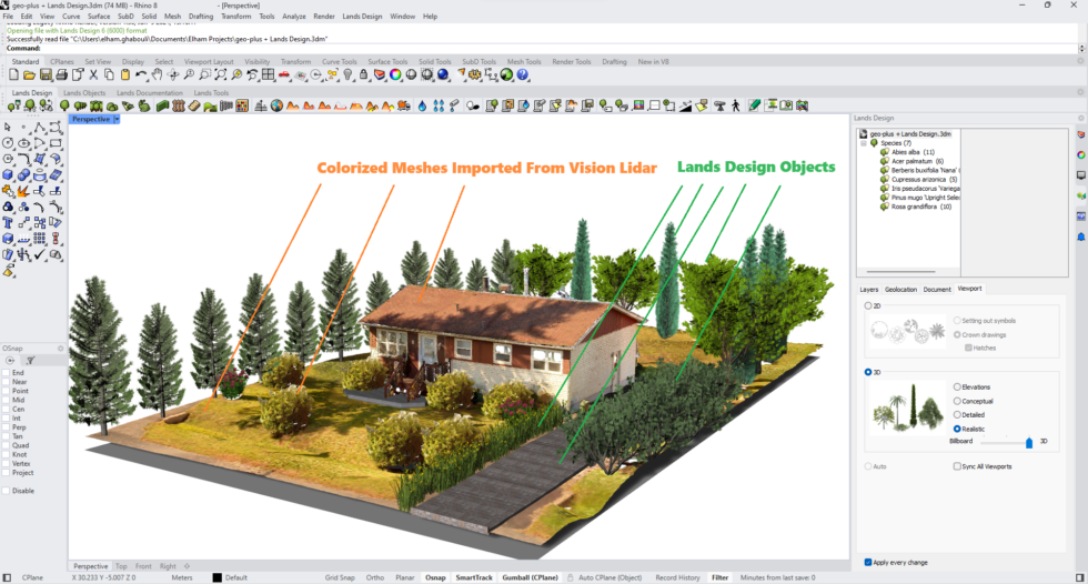
Working with the software professionals at “Lands Design” we established a workflow to integrate the colored meshes generated by VisionLidar for the “Rhino” enthusiasts.
The scanned area was converted to colorized meshes by Vision Lidar. Then, it was opened in “Rhino.” The landscape is developed using “Lands Design”
How VisionLidar to “Rhino” Works:
- Import Lidar Data: VisionLidar seamlessly imports Lidar data, capturing every nuance of the landscape.
- Dynamic Colorization: Transform point clouds into vibrant, colorized meshes, using Vision Lidar.
- Direct “Rhino” Integration: Open the colorized meshes directly in “Rhino” and use shrink wrap futures, where landscape architects can leverage “Rhino”’s robust design tools to craft stunning and functional landscapes.
You can enhance your landscape architecture projects using Lidar scanners.
Thanks to VisionLidar solution, those point clouds convert to colorized meshes. That is how you import them in “Rhino“. Then you can continue designing the landscape using “Lands Design.”
In the ever-evolving landscape of design technology, lidar stands out as a transformative tool for landscape designers. Its precision, efficiency, and ability to provide detailed insights into the natural environment empower designers to create landscapes that are not only aesthetically pleasing, but also environmentally conscious and resilient. As lidar technology continues to advance, its role in shaping the future of landscape design is sure to expand, offering designers new opportunities for innovation and creativity.