Geo-Plus

Geo-Plus | LiDAR, Land Surveying and Civil Engineering Software Solutions

VisionLidar logo on featured image
VisionLidar Logo

POINT CLOUD PROCESSING SOFTWARE

Architecture, Engineering
AND Construction

MANUFACTURING

HYDRO & UTILITIES

RAILWAYS

TRANSPORTATION

MUNICIPAL

Dive deep into our Point Cloud / LiDAR Software Features – VisionLidar

Watch the videos below to learn more on the features of our point cloud / LiDAR software, VisionLidar.

Our Point Cloud / LiDAR Software Features

  • File structure built to support and navigate thorough billion of points.
  • Spherical images tightly coupled with your point cloud.
  • Measurement tools (name, distance, angle, perimeter, area, elevation, and path).
  • Advanced classification process using unique Deep Learning GPU technology.
  • Training classification module allowing to create your own model including RGB, Intensity, or Geometry only (neural network models)
  • Virtual survey tools sharing data with your CAD systems using Feature Codes concept.
  • Volume calculations (cut and fill) including multidate comparison.
  • Unique point cloud data format for Desktop and Web (VisionLidar 365) platform.
  • Image to Scan tool converting your aerial images to point cloud.
  • Colorize point clouds from spherical images.
  • Surface creation (TIN) for bare earth extraction.
  • Import LAS, LAZ, E57, PTS, CSV, X3A, FLS, LSPROJ, WRK, RCP, RETRACE, PLY
  • Export your vector data to GeoJson, Kml, Mapinfo, Dxf, Csv, LandXML formats.
  • Export your point cloud to planimetric orthophotos (GTIFF).
  • Point Clouds to Point Cloud and Point Cloud to surface Comparison and analysis with reporting options.
  • BIM module for quick building modeling with IFC export option (walls, aperture, doors, windows, sections).
  • Road marking, Edge, Crash Barrier detection modules for asset extraction.
  • Connectivity with AutoCAD, AutoCAD Map Civil 3D, MicroStation, Microstation Connect, PowerDraft or BricsCAD.
  • Powerful colored mesh creation.

TERRESTRIAL LIDAR SCAN (TLS) and VisionLidar

  • Indoor Mapping: LiDAR scanning projects can provide 360 imaging that allows for a detailed understanding of the surveyed terrain, making it ideal for topographic and land cover mapping.
  • Mining: LiDAR data can be used to map and monitor mines, providing valuable information for mine planning, safety, and environmental management.
  • Urban planning: LiDAR surveys can be used to map urban environments, including buildings, roads, and other infrastructure, providing valuable information for urban planning and development.
  • Archaeology: Point Cloud data can be used to map and analyze archaeological sites, providing valuable information for research and preservation.
  • Safety: LiDAR can be used to assess the safety of infrastructure such as bridges and dams, providing accurate data for risk assessment and management.

MOBILE LIDAR SCAN (MLS) and VisionLidar

  • Object detection: Point cloud data can be used to detect and map objects such as buildings, trees, and power lines, providing valuable information for infrastructure planning and management.
  • Efficiency: LiDAR surveys can cover large areas quickly, safely, and efficiently, reducing the time and cost required to collect data compared to traditional survey methods.
  • High precision: LiDAR data provides highly accurate and precise measurements of elevation and topography, making it ideal for surveying projects that require accurate data.
  • Power Lines: LiDAR survey provides a range of useful information on power lines, poles and its surrounding vegetation which offer a variety analysis for clash inspection, maintenance, and assets management.
  • Railways: Mobile survey provides with a detailed 3D view of railway corridors and its neighboring environment allowing assets inventory, ballast and sleepers inspections, vegetation monitoring and safety maintenance. 

AERIAL LIDAR ALS (ALS) and VisionLidar

  • Forestry: LiDAR surveys can be used to map and monitor forest cover, identify areas of deforestation and forest degradation, and monitor wildlife habitats, providing valuable information for forestry management and conservation.
  • Flood modeling: LiDAR data can be used to model flooding events and assess flood risk, providing valuable information for flood management and emergency response planning.
  • Agriculture: Point Cloud surveys can be used to map crop yields, provide you with 3D shape of your land, and monitor soil moisture levels, providing valuable information for agricultural management.
  • Environmental monitoring: LiDAR data can be used to monitor changes in the environment, such as erosion, deforestation, and sea level rise, providing valuable data for environmental management.

Generate BIM from point clouds and so much more

Automatically detect all trees in a defined area

AUTOMATE DATA PROCESSING WITH DEEP LEARNING

Share your processed point cloud on the web

50 Reasons to Choose VisionLidar – Point Cloud / LiDAR Software Features

Discover why VisionLidar is the smartest investment for your projects by exploring the sections below to view more of our Point Cloud / LiDAR Software Features!

With VisionLidar, you can now easily visualize, process, classify, segment, animate, and edit Point Clouds in a single software. Unlike other software that limits the number of points you can process, VisionLidar can handle an infinite number of points, enabling you to work with massive Point Clouds in a single file. Process Point Clouds from ALS, TLS, and MLS for all your civil engineering, land surveying, architecture, BIM, transportation, mines, quarry, and forestry projects with ease using VisionLidar. Browse the section below to learn more about our Point Cloud / LiDAR Software Features

Dynamic 3D Fence

The dynamic 3D fence allows you to select parts of your point cloud thanks to an interior or exterior delimitation. The selection can be saved and used with different tools like editing, deleting, exporting, segmentation, classification, surface analysis, dendrometry, and cylinders and plans detection. It’s also possible to export parts of your point cloud into .E57, .LAS, .LAZ, and .PTS formats.

Adaptive cross section template

Vectorize complex 3D infrastructures with a few clicks. Roads, tunnels, and other 3D structures can be captured and converted to your CAD with the adaptive 3D and cross section template tool. Multiple alignments can be managed at the same time using different 3D templates. Cross section can be copied to the next station or interval. The user can select single or multiple points or vertex to visualize and adjust the selection to a 3D road, bridge, or tunnel. This tool also helps you create lineworks with feature codes, as well as breaklines for surface exportation into .DXF or Shape File formats.

Image and video creation

Create images, videos, and fly-throughs in your point cloud. With this tool, you can easily produce an image and save it in .PNG format. Create an intuitive time-based fly-through video in .AVI format in just a few clicks.

Color shading for surface analysis

Colorize surfaces like buildings, DTM, or any plans to visualize the deviation of the Point Cloud in different colors.

Model geometry

Extract contour lines, mesh, surfaces, planes, cylinders, trees, sidewalks, buildings, pavement lines, or any other model geometry to efficiently vectorize them. With or without a 3D fence constraint, it can easily be exported into .DXF or Shape file formats, or as a Vision Database.

Point Cloud comparison

Compare a part of two full LiDAR scans and identify their differences, then export a .PDF report. This function is adapted for building surveillance with its statistical shift tool.

Online visualization

Export to Potree to visualize and publicize your Point Cloud online. This tool allows you and your clients to easily view, measure, and annotate any Point Cloud from a Web browser.

Tree measurements

Select a region or a part of the Point Cloud using the 3D fence tool and automatically select and measure a tree height, trunk diameter, crown surface and crown diameter, from chest height. You can also choose to apply a constraint on a bare earth surface or not.

Point Cloud Management

Segment and filter your Point Cloud using the layer tool. VisionLiDAR can manage up to 128 layers to isolate parts of your scan areas for detailed editing. Rename the layers in compliance with the standards you are using such as DOT or CAD. Also visualize your Point Cloud in RGB, Normal, Scans, Intensity, Class, Wireframe, Color Shading, or Elevation. It helps you simplify your Point Cloud by eliminating irrelevant points without diminishing its accuracy.

Registration

Use a dynamic registration of Point Clouds tool to control your data and merge your scans using a least squares method.

Color shading for surface analysis

Colorize surfaces like buildings, DTM, or any plans to visualize the deviation of the Point Cloud in different colors.

Bare earth extraction

This tool allows you to extract a bare earth surface from your Point Cloud by automatically eliminating and removing vegetation, buildings, cars, humans, and other objects from the resulting mesh surface. It is particularly useful for projects where you need to visualize and analyze the characteristics of a surface. The results of your calculations are much more typical and precise.

Contour lines

Extract and draw contour lines from a surface and export them into .DXF format.

Earthwork and Complex Volumes

Calculate volumes using four different methods for maximum precision: inverted prism, grid, cross section and solid for complex vertical and overhang surface.

Road and tunnels

Vectorize complex 3D infrastructures with a few clicks, capture and convert your data to your CAD using the adaptive 3D template tool.. This tool creates cross section templates using feature codes. Multiple alignments can be managed at the same time with different 3D templates. Cross section can be copied to next station or interval. The user can select single or multiple points or vertex to visually adjust the selection to the 3D road, bridge, or tunnel. You can also use it to create lineworks with feature codes, as well as breaklines for surface exportation to .DXF or Shape file.

Alignment

Compare a part of two full LiDAR scans and identify their differences, then export a .PDF report. This functionCreate a 3D alignment from polylines, line intensity, or points with lines, as well as vertical and horizontal curves. is adapted for building surveillance with its statistical shift tool.

Infrastructure Edge Line Extraction

Automatically find the edges of a sidewalk, pavement path, building footprint, powerlines, and export them into connectivity line for break lines exportation.

Floor flatness

Verify the floor flatness analysis with a selection of your Point Cloud and colorize it into shading zones to represent differences in elevation. Then, export your results into a .PDF report.

Dynamic cross section and profile

View and click any point by setting along an alignment or two points, vertically, horizontally, or at any slop…

Online publishing

Use a dynamic registration of Point CloudsUsing Potree technology, allow your customer to easily view, measure, and annotate your Point Cloud from a simple Web browser. tool to control your data and merge your scans using a least squares method.

Slope Analysis

This intuitive tool allows you to select a surface and display a slope with colorized zones as well as slope intervals.

Model geometry

Extract contour lines, mesh, surfaces, planes, cylinders, trees, sidewalks, buildings, pavement lines, or any other model geometry to efficiently vectorize them. With or without a 3D fence constraint, it can easily be exported into .DXF or Shape file formats, or as a Vision Database.

Bare earth extraction

This tool allows you to extract a bare earth surface from your Point Cloud by automatically eliminating and removing vegetation, buildings, cars, humans, and other objects from the resulting mesh surface. It is particularly useful for projects where you need to visualize and analyze the characteristics of a surface. The results of your calculations are much more typical and precise.

Contour lines

Extract and draw contour lines from a surface and export them into .DXF format.

Earthwork and Complex Volumes

Calculate volumes using four different methods for maximum precision: inverted prism, grid, cross section and solid for complex vertical and overhang surface.

Alignment

Create a 3D alignment from polylines, line intensity, or points with lines, as well as vertical and horizontal curves.

Dynamic cross section and profile

Compare a part of two full LiDAR scans View and click any point by setting along an alignment or two points, vertically, horizontally, or at any slop…and identify their differences, then export a .PDF report. This function is adapted for building surveillance with its statistical shift tool.

Online publishing

Using Potree technology, allow your customer to easily view, measure, and annotate your Point Cloud from a simple Web browser.

Slope Analysis

This intuitive tool allows you to select a surface and display a slope with colorized zones as well as slope intervals.

Color shading for surface analysis

Colorize surfaces like buildings, DTM, or any plan to visualize the deviation of the Point Cloud in different …

Online publishing

Using Potree technology, allow your customer to easily view, measure, and annotate your Point Cloud from a simple Web browser.

Building Scanning

Building scanning is widely used for restoration and as-built. Advances in Artificial Intelligence make VisionLiDAR a software that will save you significant time and money in all your BIM projects.

Drawing

Draw directly on your Point Cloud polylines, curves, and spline, representing windows, doors, or any overhang structure.

Building models

Create models of buildings in a few steps by easily creating footprints of the building and a simplified roof symbology. Extract edges with the edge detector tool and click on a face of a building to extract all the plans in different colors.

Surface analysis

Use the surface analysis tool to check the verticality of a wall or the flatness of a floor.

Virtual visit

In a few clicks, generate an intuitive time-based fly-through video in .AVI format, just like a virtual visit.

Mesh

VisionLiDAR processes large Point Clouds very rapidly to produce a simplified mesh.

Adaptive cross section template

Vectorize complex 3D infrastructures with a few clicks. Roads, tunnels, and other 3D structures can be captured and converted to your CAD with the adaptive 3D and cross section template tool. Multiple alignments can be managed at the same time using different 3D templates. Cross section can be copied to the next station or interval. The user can select single or multiple points or vertex to visualize and adjust the selection to a 3D road, bridge, or tunnel. This tool also helps you create lineworks with feature codes, as well as breaklines for surface exportation into .DXF or Shape File formats.

Colors shading for surface analysis

Colorize surfaces like buildings, DTM, or any plans to visualize the deviation of the Point Cloud in different colors.

Model geometry

Extract contour lines, mesh, surfaces, planes, cylinders, trees, sidewalks, buildings, pavement lines, or any other model geometry to efficiently vectorize them. With or without a 3D fence constraint, it can easily be exported into .DXF or Shape file formats, or as a Vision Database.

Alignment

Create a 3D alignment from polylines, line intensity, or points with lines, as well as vertical and horizontal curves.

Online publishing

Using Potree technology, allow your customer to easily view, measure, and annotate your Point Cloud from a simple Web browser.

Slope Analysis

This intuitive tool allows you to select a surface and display a slope with colorized zones as well as slope intervals.

Colors shading for surface analysis

Colorize surfaces like buildings, DTM, or any plans to visualize the deviation of the Point Cloud in different colors.

Bare earth extraction

This tool allows you to extract a bare earth surface from your Point Cloud by automatically eliminating and removing vegetation, buildings, cars, humans, and other objects from the resulting mesh surface. It is particularly useful for projects where you need to visualize and analyze the characteristics of a surface. The results of your calculations are much more typical and precise.

Earthwork and Complex Volumes

Calculate volumes using four different methods for maximum precision: inverted prism, grid, cross section and solid for complex vertical and overhang surface.

Tree measurements

Select a region or a part of the Point Cloud using the 3D fence tool and automatically select and measure a tree height, trunk diameter, crown surface and crown diameter from chest height. You can also choose to apply a constraint on a bare earth surface or not.

Point Cloud Management

Segment and filter your Point Cloud using the layer tool. VisionLiDAR can manage up to 128 layers to isolate parts of your scan areas for detailed editing. Rename the layers in compliance with the standards you are using such as DOT or CAD. Also visualize your Point Cloud in RGB, Normal, Scans, Intensity, Class, Wireframe, Color Shading, or Elevation. It helps you simplify your Point Cloud by eliminating irrelevant points without diminishing its accuracy.

Bare earth extraction

This tool allows you to extract a bare earth surface from your Point Cloud by automatically eliminating and removing vegetation, buildings, cars, humans, and other objects from the resulting mesh surface. It is particularly useful for projects where you need to visualize and analyze the characteristics of a surface. The results of your calculations are much more typical and precise.

Automatic vegetation classification

VisionLiDAR’s unique algorithm automatically classifies vegetation limited by a 3D fence to separate up to 128 layers and isolate species.

Our Point Cloud / LiDAR Software Features

lidar software features

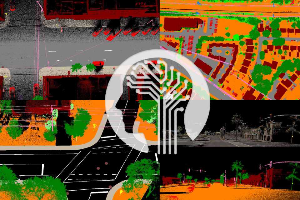
AI CLASSIFICATION PROCESS

Powerful Deep Learning classification process which uses the latest AI technology to segment your point cloud over our 250 classes. Use our predefined models to classify your terrestrial or airborne data. Create multiple iterations to refine your segmentation and get the maximum control of your 3D data. 

AI ANNOTATION AND TRAINING

Create your own AI Classification model according to your scanner signature (RGB, Intensity, points cloud geometry). Use our powerful selection tools to annotate elements you want to classify and get a new model compiled according to your project specifications. Get the full control of your projects with VisionLidar.
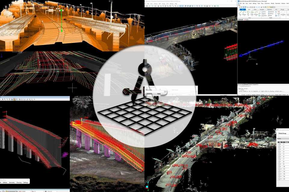
ASSETS EXTRACTIONS

Do your virtual survey inhouse, extract points and chains with your own feature codes. Use our semi automatic tools to get pavement lines from intensity, vectorize edges, curbs, or crash barriers. Get poles and cables extracted directly from their own class. Export your results to CADs and GIS.

INTEROPERABILITY WITH CAD

Synchronize your cad with your point cloud data and vectorize directly in your own controlled environment. Follow the market standards to create your deliverables by using your customer feature codes. Store your points and chains in a database connected to your cad by using our visioncivil module.

BARE EARTH AND SURFACE ANALYSIS

Extract bare earth surfaces (dem, dtm) from your point cloud data by using artificial intelligence to eliminate vegetation, buildings, cars, pedestrians, and other objects. Create contour lines from the surface, add brake lines, different algorithms to calculate volume with one scan or difference between 2 scans. 

3D STRUCTURE ANALYSIS

Monitor surfaces, buildings, and structures by visualizing deviations and irregularities. Use planes to validate the verticality and the flatness of walls, ceilings, and floors. Compare two scans to monitor changes over the time. Share your observations by using reports      

CROSS SECTION AND PROFILE

Create point cloud cross section directly in visionlidar and analyse or validate your data. Use our module visioncivil to create alignments and extract cross sections or profiles from your surfaces and draw them directly on your own cad system.

SPHERICAL IMAGE

A picture is worth a thousand words so imagine a spherical image. Get in an immersive street view of your projects by mixing your point cloud data with an RGB image. Visionlidar also provides different algorithms to colorize your point cloud or create spherical images from your point cloud

VISUALISATION AND CLIPPING TOOLS

Visualize your point cloud projects by color, intensity, classes, elevation, distances or scans. Quick and easy control of your classes (renaming, color, templates number of points). Save and name your fences to organize your different views. Hide portion of your point cloud data in 3d by using clipping box. Wysiwyg export tool, what you see is what you export.

VisionLidar Brochure – Our Point Cloud / LiDAR Software Features

VisionLidar is a powerful software that allows you to process and analyze point clouds and 360 images from a range of sources, including aerial, terrestrial, and mobile LiDAR data. With a wide range of features, our point cloud / LiDAR software VisionLidar, lets you classify objects, visualize and edit point clouds, and extract valuable information from your data with ease.

Whether you are working on civil engineering, land surveying, architecture, transportation, or any other project that requires precise 3D data, VisionLidar the point cloud / LiDAR processing software has the tools and the features you need to get the job done efficiently and effectively.

Keep reading to learn more about our Point Cloud / LiDAR Software Features and the capabilities of VisionLidar and how it can benefit your work.

VisionLidar Logo lidar software features page
Scroll to top