
VisionLidar – Point Cloud Processing Software
VisionLidar is an advanced Point Cloud Software offering high-performance processing, advanced data visualization, and automated tools for increased productivity. Its cutting-edge technology, including deep learning for semantic segmentation, makes it ideal for creating 3D models, surveying, and mapping applications.

Architecture, Engineering
AND Construction

MANUFACTURING

HYDRO & UTILITIES
RAILWAYS
TRANSPORTATION

MUNICIPAL
Altogether, VisionLidar is an advanced Point Cloud Software that offers a wide range of features, catering to professionals and industry specialists alike.
High-performance processing with VisionLidar
VisionLidar is a Point Cloud Software that can process large datasets quickly and efficiently, making it an ideal choice for professionals who need to work with large point cloud projects. Additionally, it offers advanced features for data analysis and visualization.
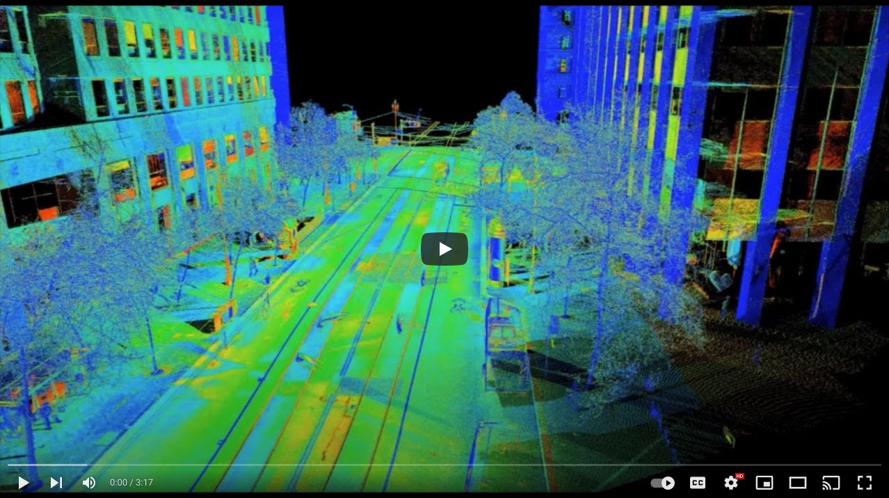
Advanced visualization using VisionLidar
The software offers a wide range of visualization options. For instance, users can view spherical images overlaid on lidar data using a powerful 3D viewer. This functionality allows users to explore and analyze their point clouds with ease.
Automated processing with VisionLidar
Our Lidar Software comes equipped with a variety of automated processing tools, thus ensuring users can save time and increase productivity. Among these tools are features for noise reduction, classification, and feature extraction, all of which are designed to streamline workflows efficiently.
VisionLidar High end technology
VisionLidar is at the cutting edge of technology, incorporating semantic segmentation (classification) through deep learning. This innovative approach enables users to create customized models specifically tailored to their sensors and unique requirements, thereby ensuring optimal performance and adaptability.
Use our Point Cloud Processing Software specifically for creating 3D models, surveying, and mapping applications, among other LiDAR applications.
Overall, VisionLidar represents a powerful and flexible point cloud software, boasting a wide array of advanced features suitable for professionals and enthusiasts alike. Additionally, for those seeking a high-performance and customizable solution for handling large point clouds, VisionLidar proves to be an excellent choice.

Above all, you can have your LiDAR & Point Cloud Processing Software Quotation straightaway!
Whether you’re an Engineer or a Land Surveyor, which VisionLidar package is right for you?
At first, this is a great start for your projects
Standard Package
Unquestionably the Most popular
Premium Package
So far the most Extensive in integrations & connectivity
Ultimate Package
VisionLidar the Point Cloud Software with features that change the face of the industry!
Experience seamless point cloud processing or lidar processing software with powerful tools such as Deep Learning classification, volume calculation or comparative analysis between two point clouds or between a surface and a point cloud. Add to this, our automated tools for break lines or edges detection, poles, or trees (including diameter at breast height DBP, crown, height of the top etc.) or also linear pavement marking and guardrails.
For those who are familiar with the CAD environment, use our Ultimate version and get connected to your favorite platform and take advantage of our virtual surveying tools that use industry standards. Easily export your data to multiple formats such as GeoJson, Kml, Mapinfo, Dxf, Csv, LandXML. Improve the interpretation of your environment by using spherical images (360) directly in our 3D interface. With a user-friendly interface and intuitive tools, explore your point cloud data with ease and accuracy.
You can always push your limits by sharing your data and point clouds while collaborating with your customers. Additionally, utilize our online platform VisionLidar 365 for seamless communication and teamwork.
Put VisionLidar the Point Cloud / LiDAR Processing Software to the test!
Additionally, obtain the limited version by filling out the form to generate your download link.
Do you want to
Share Point Cloud on the Web?

WEB POINT CLOUD SHARING PLATFORM
Governments and Companies that use VisionLidar the LiDAR processing software
Express your gratitude to all of our loyal customers, both nationally and internationally, who have worked with us throughout the years. Moreover, thank you for your confidence in our services.


8 thoughts on “VisionLidar”
Comments are closed.